


Motion Sensors
Return to HydrographicSearch products
X Products selected
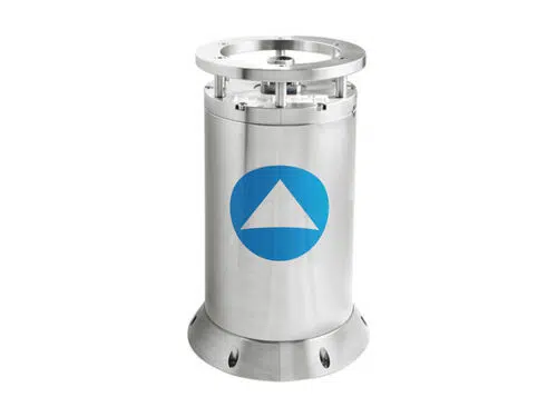
iXblue Octans 3000
OCTANS 3000 is a subsea survey-grade gyrocompass and complete motion sensor for water depths up to 3,000 m.
OCTANS 3000 is a subsea survey-grade gyrocompass and complete motion sensor for water depths up to 3,000 m. Based on iXBlue’s fiber-optic gyroscope (FOG) technology it outputs heading, roll, pitch, heave, rate of turn and acceleration. OCTANS 3000 can be easily upgraded to full INS mode (i.e. ROVINS).
- Complete gyrocompass and motion sensor
- smart HeaveTM
- Fiber-optic gyroscope (FOG), unique strap-down technology
- Ethernet, web-based man-machine interface (MMI)
- Titanium made, small, portable plug and play system
- Optional full featured inertial navigation system
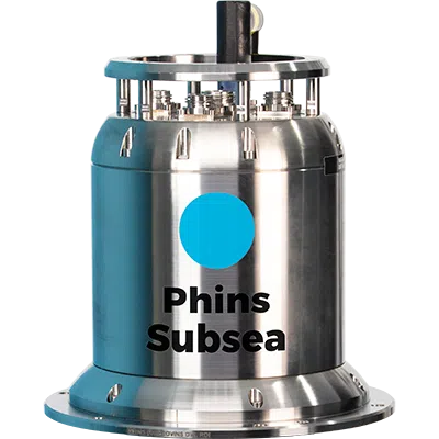
iXblue PHINS 6000 Subsea
PHINS 6000 is a subsea inertial navigation system (INS) providing position, true heading, attitude, speed, depth, and heave for deep water operations.
PHINS 6000 is a subsea inertial navigation system (INS) providing position, true heading, attitude, speed, depth, and heave for deep water operations. Its high-accuracy inertial measurement unit is coupled with an embedded digital signal processor that runs an advanced Kalman filter. PHINS DVL Ready is pre-assembled and pre-calibrated with a Doppler velocity log version making the system easy to install and ready to use for more precise navigation.
Features:
- All-in-one high-accuracy 3D positioning with heading, roll and pitch
- FOG, unique strap-down technology
- Multiple aiding available: (DVL, USBL, LBL, RAMSES, GPS, depth sensor)
- Options: DVL or RAMSES coupling
- Ethernet, web server (GUI)
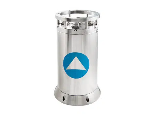
iXblue ROVINS
ROVINS is a combined survey-grade full featured Inertial Navigation System (INS) for water depths up to 3,000m.
ROVINS is a combined survey-grade full featured Inertial Navigation System (INS) for water depths up to 3,000m. Designed specifically for offshore survey and construction works, ROVINS improves the efficiency of all operations where accurate position, heading and attitude are key benefits.
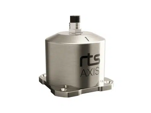
RTS AXIS
The RTS AXIS is a high-accuracy subsea pitch and roll sensor. The unit provides an absolute accuracy of 0,1 degrees from -60 to +60 degrees across both axis with exceptional repeatability. This makes the RTS AXIS an excellent choice for checks and verifications during subsea inspection and construction work.
The 4000 meter rated titanium housing, measurement-optimized base plate, small size and low power consumption provides the user with a robust and flexible unit for subsea measurements.
- Titanium housing
- High Accuracy Sensor
- Excellent Repeatability
- +/-60 degree range
- Small size
- Low power consumption
- 4000 MSW depth rating
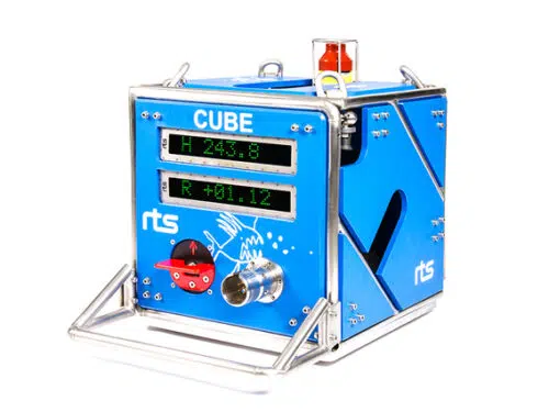
RTS CUBE
The RTS CUBE is an advanced self-contained subsea instrument package for monitoring heading, pitch, roll, depth and other user-specified parameters. The unit is scalable and can be configured as a straightforward battery-operated gyro with subsea displays or as a complex logging solution for a host of different sensors.
Examples of applications:
- Monitoring heading and inclination during descent and deployment of subsea structures
- Monitoring differential pressure inside suction anchors during deployment to avoid implosion
- Alignment and placement of pipes
- Wellhead installation
- Long term monitoring of subsea installations with automated wake-up and sleep functionality
- Post installation monitoring
The system can provide the user with live data and graphical displays of the required parameters (and optional video) via an acoustic modem or hot stab connection. This will aid the user in decision-making during critical operations and make sure specified tolerances and safety requirements are upheld. The collected CUBE data is supplied as a deliverable and can be replayed post-operation.
The CUBE consists of a frame containing system controller and logger, gyro, subsea displays, battery, acoustic telemetry, ROV-operated switch, ROV hot stab and optional auxiliary sensors.
- Remote configuration
- 32Gb Internal logger
- Intuitive control and display software
- High accuracy
- Robust construction
- Sensor flexibility
- ROV connection
- Advanced subsea display features
- External sensor capabilities
- Remote system startup (air and water)
- Tailored surface logging software
- Simple setup
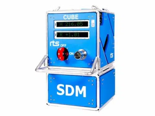
RTS CUBE SDM
The RTS CUBE SDM is a self-contained monitoring solution for subsea structures. It is used during the deployment and installation phase but can also be utilized for long-term monitoring to ensure structure stability and position.
In addition to monitoring heading, deflection and suction can pressure, the system can also provide the user with live video and a number of optional sensors. Based on a proven track record the RTS CUBE SDM is the second generation of SDM systems and offers unparalleled performance and control during critical operations.
- Real-time comprehensive structure monitoring
- Software for presentation, control and calibration
- Logging and time-stamping of all sensor data
- Wireless system testing and logging
- Real-time tide compensation (RTC)
- Robust and compact construction
- ROV connection
- Sensor choice flexibility
- Data output for third party software
- Simple setup
- Engineered based on proven track record
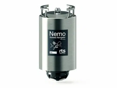
RTS Nemo Subsea Navigator
The RTS NEMO Subsea Navigator is a combined INS and DVL solution for water depths up to 4000m. The unit is purpose-built for ROV navigation and features state-of-the-art field proven components from renowned subsea manufacturers iXblue, Nortek and RTS.
NEMO has been designed for maximum reliability with such features as maintenance-free power drop-out protection, titanium housing and connectors and FOG technology. NEMO comes ready-calibrated in a robust single housing. The remarkably compact size and low weight of the NEMO and customizable mounting brackets makes it ideal for placement on a large range of ROVs from observation-class to work-class.
- All-in-one Navigation System
- Fully calibrated (one housing)
- Compact size
- Titanium housing
- iXblue and Nortek Inside ®
- INS & DVL in separate watertight compartments
- Maintenance-free FOG technology
- Power drop-out protection (battery-free)
- 4000m depth rating
- Current Profiler
- Spectrum Analyzer
- Web interface for direct control and monitoring of DVL and INS
- Engineered for extreme reliability
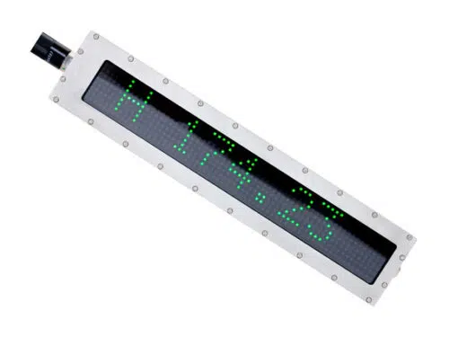
RTS TEXT
Precision visibility for subsea applications. The new RTS Subsea Display features leading edge functionality and sought after improvements for displaying information subsea.
The RTS Engineering team introduces a unit that will provide unparalleled visibility, flexibility and up to one-tenth of the power consumption of existing product solutions. Features such as automated light sensitive startup, bar graph display, limit value indication and customized colors supplies the operator with more indepth information for more effective decision-making. Also, the compact design allows for a wide range of applications while still maintaining 4k ocean depth rating.
- High visibility
- Low power consumption
- Full RGB LED
- Flexible interface
- Adjustable colors and intensity
- 4000 MSW depth rating
- Compact construction
Sonardyne SPRINT System
SPRINT is an acoustically aided Subsea Inertial Navigation system for subsea vehicles. SPRINT makes optimal use of acoustic aiding data from acoustic USBL and LBL positioning and other sensors such as Doppler Velocity Log (DVL) and pressure sensors. This improves position accuracy, precision, reliability and integrity while reducing operational time and vessel costs. The system extends the operating limits of Ultra- Short BaseLine (USBL) and can dramatically improve the operational efficiency of Long BaseLine (LBL). The new third generation SPRINT unit offers power pass-through to aiding sensors, reducing cabling and interfacing complexity.
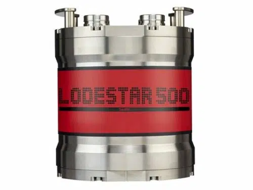
SPRINT INS shares the same hardware platform as Lodestar AHRS and is a combined AHRS (Attitude Heading Reference System) and AAINS (Acoustically Aided Inertial Navigation System). Running both the AHRS and INS algorithms concurrently allows inertial navigation to start or restart instantaneously on receipt of a position update as the AHRS seamlessly provides orientation to the INS on start-up. This avoids the lengthy ‘alignment’ period common to other INS systems. Thereafter, the separate AHRS and INS computed orientation are autonomously monitored as an indication of system health.
All AHRS and AAINS computations are performed within the Lodestar, making the system robust and resilient to communications issues. Lodestar maintains a rolling 15 day backup of all real time navigation and raw data on an onboard SD card which can be retrieved if required. Coupled with concurrent logging of all data by the topside software, data integrity is ensured.
- Popular for navigating ROVs and AUVs
- Speeds up operations – saves you vessel time
- Small, lightweight and easy to install
- Track record spanning more that 10 years
- Range of performance levels to suit your task
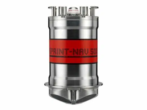
Sonardyne SPRINT-Nav 500
SPRINT Nav is an all-in-one subsea navigation instrument for underwater vehicles. t combines Sonardyne’s SPRINT INS, Syrinx DVL 600 kHz (Doppler Velocity Log) and high accuracy intelligent pressure sensor in a single housing that is one of the smallest combined inertial navigation instruments on the market.
The unit is comprised of three high grade Ring Laser Gyros (RLG) and accelerometers. These ultra-reliable sensors are used also for safety critical navigation by the majority of the world’s large commercial aircraft and do not require factory recalibration over the product’s lifespan.
SPRINT-Nav’s dual algorithm capability is unique in the market and allows for simultaneous use from one instrument, e.g. AHRS plus DVL for ROV piloting, INS plus DVL for survey operations.
The SPRINT and Syrinx components can be operated as standalone sensors, independently of one another depending on the need. SPRINT-Nav is calibration free.
With power-pass-through, aiding sensors can be powered directly, reducing cabling cost and complexity. Sensor offsets are rigid and very accurately known, helping to reduce systematic errors in lever arm measurements. The pressure sensor module can be removed for calibration or repair without incurring downtime.
Each Syrinx transducer is fitted with a full depth rated water block to ensure protection of the internal components.
- World’s highest performing hybrid navigator
- All-in-one turn-key solution
- Dual concurrent AHRS, INS and
- DVL output capability for multi-use
- Instantaneous INS initialisation from AHRS with no alignment
procedure required - Dual AHRS & INS algorithms enabling internal health check of orientation
- Highly optimised SWaP
- Proven long life and high MTBF inertial sensors from trusted longterm US supplier
- Remote diagnostics and performance verification
- Fully water blocked DVL endcap protecting internal electronics
- 0.4–175 m bottom track operating range
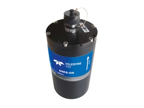
Teledyne TSS DMS-05
The DMS range of motion sensors is designed specifically for the motion measurement needs of the marine industry. Whether it is achieving IHO standard survey from any size of vessel, or providing safety critical monitoring of offshore platforms, large vessels, helicopter landing decks, cranes and positioning systems, the DMS provides accurate motion measurement in all sea conditions.
Incorporating an enhanced external velocity and heading aiding algorithm for improved accuracy during dynamic manoeuvres, the solid state angular rate sensors offer reliability in the highest performing vertical reference unit ever produced by TSS.
The DMSView software programme is an intuitive WindowsTM – based programme enabling installation, set-up and integrity checking, and monitoring of the sensor. The user can select from a series of frequently used data protocols or configure a bespoke output from a selection of variables.
The DMS is rated to 3000m as standard with 6000m available on request. The sensor can be supplied in various configurations for integration with towed vehicles and other bespoke applications. As with all TSS systems, the DMS is certified to meet all current and anticipated European legislation for electromagnetic compatibility and electronic emissions.
- Dynamic roll and pitch accuracy to 0.05°
- Depth rated to 3000m (optional 6000m)
- Survey to Class 1 IHO standard
- High dynamic accuracy during vessel turns
Teledyne TSS Saturn 30
The latest generation of marine navigation system. The Saturn fibre optic gyrocompass capitalises on more than a century’s experience in marine navigation. Teledyne TSS’ own experienced and innovative engineering team has combined the latest solid state technologies and calibration techniques to offer a user-friendly, highly accurate and cost-effective navigation solution for demanding marine environments.
The Saturn 30 Subsea, is primarily designed for subsea ROV navigation.
All subsea versions are housed in 4000m rated titanium casings ensuring durability, reduced weight and size, and reduced corrosion when compared to aluminium casings.
- Heading, pitch, roll and heave outputs
- Full inertial position from Saturn 10
- Easy to use Saturn web interface
- Compatible with GPS, DVL, USBL and LBL
- Raw output data format supported
- Subsea titanium rated to 4000m as standard